
Category:Mid-Atlantic Ridge
- (en) Mid-Atlantic Ridge
- (ca) Dorsal mesoatlàntica
- (cs) Středoatlantský hřbet
- (da) Midtatlantiske ryg
- (de) Mittelatlantischer Rücken
- (es) Dorsal mesoatlántica
- (et) Kesk-Atlandi mäestik
- (eu) Dortsal mesoatlantikoa
- (fr) Dorsale médio-atlantique
- (gl) Dorsal mesoatlántica
- (he) הרכס המרכז-אטלנטי
- (is) Atlantshafshryggurinn
- (it) Dorsale medio atlantica
- (ja) 大西洋中央海嶺
- (ko) 대서양 중앙 해령
- (ksh) Meddel Atlanntish Rögge
- (nl) Mid-Atlantische Rug
- (nn) Den midtatlantiske ryggen
- (no) Den midtatlantiske ryggen
- (pl) Grzbiet Śródatlantycki
- (pt) Dorsal meso-atlântica
- (ru) Срединно-Атлантический хребет
- (scn) Dursali Mediu Atlàntica
- (sl) Srednjeoceanski hrbet
- (sr) Атлантско-океанска област
- (sv) Mittatlantiska ryggen
- (sw) Mgongo kati wa Atlantiki
- (tr) Orta Atlantik Sırtı
- (uk) Серединно-Атлантичний хребет
- (vi) Sống núi giữa Đại Tây Dương
- (zh) 大西洋洋中脊
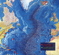
Atlantic Ocean tectonic plate boundary  Карта возраста океанического дна. Срединно-Атлантический хребет — самая молодая (показано красным) часть дна Атлантического океана  Батыметрычная карта Атлантычнагатакіяна | |||||
| Upload media | |||||
| Instance of | |||||
|---|---|---|---|---|---|
| Location | international waters | ||||
| Located in or next to body of water | |||||
| Has part(s) |
| ||||
| Heritage designation |
| ||||
 | |||||
Subcategories
This category has the following 19 subcategories, out of 19 total.
A
- Atlantis Fracture Zone (2 F)
E
G
J
L
- Logatchev Hydrothermal Field (17 F)
M
R
- Rainbow Vent Field (13 F)
- Romanche Trench (1 F)
S
- Snake Pit Hydrothermal Field (26 F)
T
Media in category "Mid-Atlantic Ridge"
The following 28 files are in this category, out of 28 total.
-
 1st-SOUSE-sensors.png 300 × 280; 155 KB
-
.gif/120px-Analogue_Model_of_extension_tectonics%2C_forming_of_Normal_Fault_and_Diapirs_(salt_dome).gif)
-
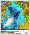
 Arctic Ocean bathymetric features.png 803 × 664; 664 KB
-
.jpg/120px-Atlantic_bathymetry_(cropped_-_South).jpg) Atlantic bathymetry (cropped - South).jpg 2,683 × 2,108; 3.22 MB
Atlantic bathymetry (cropped - South).jpg 2,683 × 2,108; 3.22 MB
-
 Atlantic Central Ridge.JPG 490 × 653; 98 KB
-
 Atlantic Ocean surface.jpg 982 × 958; 249 KB
-
 Atlantic Oceanic-Crust.jpg 600 × 600; 301 KB
-
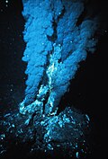 Blacksmoker in Atlantic Ocean.jpg 1,208 × 1,780; 1.76 MB
-
 Cape Verde Rise.jpg 1,825 × 2,000; 1.22 MB
-
 Charlie-gibbs-full-extent.png 1,020 × 626; 310 KB
-
 Charliegibbsschema-en.svg 1,052 × 744; 18 KB
-
 Cratons West Gondwana AR.svg 745 × 710; 170 KB
-
 Cratons West Gondwana IT.svg 745 × 710; 170 KB
-
 Cratons West Gondwana-es.svg 745 × 710; 196 KB
-
 Cratons West Gondwana.svg 745 × 710; 170 KB
-
.jpeg/120px-Divia_briandi_(MNHN-IM-2000-32536).jpeg) Divia briandi (MNHN-IM-2000-32536).jpeg 7,087 × 4,961; 4.24 MB
Divia briandi (MNHN-IM-2000-32536).jpeg 7,087 × 4,961; 4.24 MB
-
 DUPAL.png 1,019 × 529; 28 KB
-
 Expl2221 - Flickr - NOAA Photo Library.jpg 1,920 × 1,080; 550 KB
-
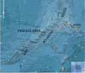 FAMOUS on MAR.svg 917 × 784; 3.85 MB
-
 IBCAO betamap.jpg 762 × 868; 710 KB
-
 Internal wave breaking in the Rainbow Ridge.jpg 2,400 × 1,800; 1.11 MB
-
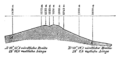 Meyers b2 s0003 b1.png 392 × 188; 18 KB
-
 Mid-atlantic ridge map.png 200 × 415; 21 KB
-
 NAM-SAM-AFR-triple junction.jpg 800 × 800; 209 KB
-
.jpg/120px-Thingvellir%2C_Iceland_(21677114683).jpg) Thingvellir, Iceland (21677114683).jpg 4,608 × 3,072; 1.51 MB
Thingvellir, Iceland (21677114683).jpg 4,608 × 3,072; 1.51 MB
-
 Vemafracturezone-qgis.svg 1,052 × 744; 2.34 MB
-
 Vematransform.svg 1,020 × 609; 393 KB
-
 WalvisRidge.jpg 541 × 419; 104 KB

.gif)

.jpg)


.jpeg)


.jpg)


Categories:
- Volcanism of the Atlantic Ocean
- Mid-ocean ridges of the Atlantic Ocean
- Structural geology of Europe
- Geology of North America by important geologic unit
- Structural geology of Africa
- Structural geology of South America
- Geology of the Atlantic Ocean
- Rift zones (extensional regime)
- Landforms of the Atlantic Ocean
- Submarine volcanism of the Atlantic Ocean
- Volcanoes in the Atlantic Ocean
- Tentative List for future World Heritage Sites in Portugal
- Fault zones in Europe
- Topography of the Atlantic Ocean
- Magmatism of the Atlantic Ocean